Except for members of the Flat Earth Society, everyone accepts that the Earth is roughly spherical. This spherical shape has some major drawbacks for the mapmaker faced with producing a flat map that correctly represents the shapes, angles, distances, and sizes of objects on the Earth. In simple terms, projecting the Earth’s surface onto a plane will always result in some sort of distortion. Peel an orange and try to flatten the peels on a table; now you have a visual idea of the problem that the mapmaker faces. Visualizing the projection of the three-dimensional Earth onto a flat surface using an orange peel is simple. Making a map representing the three-dimensional Earth is much more involved. But have no fear: In this section, I walk you through the process.
Eratosthenes calculated the Earth’s circumference more than 2,200 years ago—using only shadows, geometry, and a keen scientific mind.
Measuring the Earth
Way back in the third century B.C., a Greek scholar by the name of Eratosthenes first calculated the circumference of the Earth. Often considered the founder of geography, this ancient Greek scholar was the first to record the use of a grid system to map, or model, the Earth’s surface. How the Earth is measured and modeled for mapping purposes is the basic concept behind geodesy. Geodesy is the science behind measuring and understanding the Earth’s shape, size, gravity field, and how those aspects change over time.
In the early days, geodesy involved measuring the Earth using techniques like triangulation, which determines distances by measuring angles between points to form a series of interconnected triangles. This method worked fairly well. In fact, it’s the method Eratosthenes used to measure the circumference of the Earth, and he came within two percent of the actual value. That’s pretty close, if you ask me! Today, we have advanced technologies, like GPS, that use satellites to continuously monitor the size and shape of the Earth.

Identifying, locating, and measuring features on the Earth’s surface for use in mapping, engineering design, construction, and other related activities require more than what you might learn by simply peeling an orange. To start, you need a basic understanding of some key concepts for representing the Earth’s three-dimensional, curved shape.
The Earth is not a perfect sphere. It’s flattened at the poles, it bulges at the equator, and it’s lumpy with mountains and canyons across its surface. These imperfections cause gravity to pull on everything in different directions and at different strengths. As you may imagine, these complexities make it difficult to map Earth’s surface. Fortunately, geodesists, or scientists who specialize in geodesy, have developed two mathematical models of the Earth’s surface, the geoid and the ellipsoid, that make it easier to measure and map the Earth, despite its many imperfections. Although they may sound similar, the geoid and the ellipsoid are used differently.
What challenges do you think arise when trying to represent a bumpy, irregular Earth on a flat map?
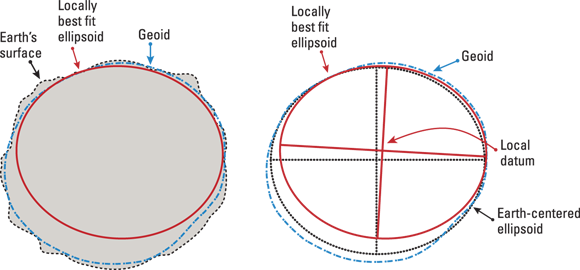
The geoid is a model of Earth’s shape that accounts for its uneven gravity field. Rather than being a perfect sphere, the geoid reflects the pull of Earth’s gravity, with areas that rise and fall due to the variations in mass across the planet. The geoid is important for defining accurate elevations relative to the average sea level, but because it’s so complicated, it’s not ideal for mapping or surveying.
This is where an ellipsoid comes in. An ellipsoid is a mathematically simplified shape that approximates the Earth’s surface, smoothing out the lumpiness to create a more manageable surface than a geoid provides. An ellipsoid is the shape commonly used for building reference systems, which are necessary for accurate mapping, surveying, and navigation. A reference system is a framework used to define and measure locations on the Earth’s surface.
Why do you think mapmakers use both the geoid and the ellipsoid, instead of just one model for everything?
I have thrown out a lot of new terms in this section, so I know it can be tricky to take them all in. But don’t fret! Even seasoned GIS professionals often confuse the terms geoid and ellipsoid, so here’s a more in-depth description of each:
-
 TECHNICAL STUFF
Geoid: The geoid is a model of the Earth’s shape based on gravity. It represents an imaginary surface where the ocean would settle if no tides, winds, or currents existed. Essentially, it would be as though the average sea level extended across the entire planet. This surface is shaped by variations in Earth’s gravity, meaning that it’s not a perfect sphere or ellipsoid. Scientists use the geoid as a reference to measure elevation and understand how gravity affects the planet.
- Ellipsoid: An ellipsoid is a sphere shape that is slightly flatter at the poles and thicker at the equator. It serves as a reference surface for measuring the Earth. Before Earth-orbiting satellites came along, people created ellipsoidal models for a best fit across continent-sized regions. But an ellipsoid that fits North America may not be useful if you’re working in Australia. As a result, many different ellipsoids have been created to get accurate measurements based on where your project is located. Today, the most commonly used ellipsoids are the Geodetic Reference System of 1980 (GRS80) and the World Geodetic System of 1984 (WGS84).
The science of measuring and understanding the Earth’s shape, size, gravity field, and how those aspects change over time.
A framework used to define and measure locations on the Earth’s surface, crucial for mapping and navigation.
Figure 2-4 is a simple depiction of how the geoid and ellipsoid relate to each other and the Earth’s surface.
© John Wiley & Sons, Inc.
Earth’s shape is a perfect sphere, so mapping it flat should be straightforward.
The Earth is irregular—flattened at the poles, bulging at the equator, and lumpy—so modeling and mapping it accurately requires complex mathematical models like the geoid and ellipsoid.
Surveyors and engineers rely on precise Earth models to plan infrastructure like bridges, tunnels, and pipelines—small miscalculations due to ignoring Earth’s irregular shape can cause costly errors.
Modern GPS units use global ellipsoid models (like WGS84) to calculate positions anywhere on Earth, but accurate elevation still depends on local geoid models.
Want to go deeper? The science behind the geoid and ellipsoid
The geoid is not a simple mathematical surface, but a complex “equipotential surface” where gravity is equal everywhere. It’s measured using sensitive instruments and satellite data. The ellipsoid, on the other hand, is defined by two axes: the semi-major axis (equator) and the semi-minor axis (poles). By adjusting these, geodesists create ellipsoids that best fit specific regions or the whole planet. Modern global mapping now favors Earth-centered ellipsoids like WGS84, which, while not perfect, provide a consistent reference for worldwide navigation.
Experience firsthand the challenge of flattening a round surface:
- Take an orange and peel it in as few pieces as possible.
- Try to lay the peel flat on a table without tearing it further.
- Observe where the peel wrinkles, tears, or overlaps. Reflect: What does this illustrate about projecting the Earth’s surface onto a flat map?
How does the orange peel activity help you understand the challenges mapmakers face?
Geoid
Tap to revealA model of the Earth’s shape based on gravity, representing an imaginary sea level surface shaped by variations in Earth’s mass.
Ellipsoid
Tap to revealA mathematically simplified shape that approximates the Earth’s surface, slightly flattened at the poles and bulging at the equator.
Triangulation
Tap to revealA technique for measuring distances by forming a network of triangles, historically used in early geodesy to calculate the size of the Earth.
Which model is primarily used to define accurate elevations relative to mean sea level?
No flat map can perfectly represent the Earth’s surface without distortion—understanding the geoid and ellipsoid models is essential for accurate mapping and navigation.
Geodesy provides the scientific foundation for all geographic measurements, making modern GPS and precise engineering possible.
Imagine you are a GIS professional tasked with mapping an area that spans both mountains and lowlands. How would the concepts of geoid and ellipsoid affect your approach to accurately representing elevation and distance?
- The Earth’s irregular shape creates challenges for making flat maps.
- Geodesists use mathematical models—the geoid and ellipsoid—to address these challenges.
- Reference systems and advanced technology enable accurate mapping and navigation worldwide.
Peel an orange and try to flatten the peels on a table; now you have a visual idea of the problem that the mapmaker faces.
How confident are you that you can explain the difference between the geoid and the ellipsoid in Earth modeling?