Maps are fundamental to GIS. They provide a way for you to transform your spatial data into a meaningful, easy-to-understand visualization. By knowing how maps represent spatial data and the different types of maps you can create — such as reference, thematic, and topographic maps — you can learn how to visualize geographic relationships and patterns. In this section, I guide you through the essentials of mapping in GIS, including how maps use symbols to communicate information and the importance of scale for representing the Earth’s surface.
Some of the earliest maps date back over 8,000 years and were carved on clay tablets—long before paper or digital displays existed!
Seeing how maps represent spatial data
GIS enables you to visualize your spatial data by using symbols that represent real-world features. It helps you discover patterns and relationships within your data so that you can make informed decisions. With the aid of colors, symbols, and lines to display attributes of your spatial data in a map, you can make complex information understandable to any audience. For example, a traffic map might use different colors to indicate congestion levels, simplifying the understanding of urban mobility issues. This capability to represent and analyze data visually is what makes GIS an invaluable tool for anyone needing to interpret geographical contexts quickly and effectively.
Want to go deeper? The science behind map symbols and colors
Mapmakers carefully select symbols and colors to ensure clarity and avoid misinterpretation. For example, red is often used for major roads because it stands out, while blue is reserved for water features. Cartographers use conventions and research from cognitive science to design maps that communicate effectively and minimize confusion.
What is an example of a real-world decision that could be improved using a well-designed GIS map?
Reviewing types of maps
Anyone who creates a map must consider the content and subject of the map. They must assign a topic, or theme, to the map and set the individual details in the proper context. If you’re creating a map to your house-warming party, for example, you must include roads so that your guests know how to get there. Landmarks and buildings may also help your guests get oriented to your part of town. You can even include text on the map, such as “Turn left at the ugly purple house.”

In a technical conversation, words often have different or more precise meanings than in a general conversation. The context and the theme are just as important in mapping as they are in a general conversation. A map needs a unique context, a specific vocabulary, and a set of rules that pull all these parts together so that both the mapmaker and the map reader can understand each other.
The easiest way to categorize maps is to separate them into three basic groups: reference maps; thematic maps; and topographic maps.
A map that combines various types of information (like political boundaries, roads, and natural features) to provide a general overview of a region.
A map focused on communicating detailed information about a specific topic or theme, such as population density or road types.
Reference maps
Reference maps offer a great deal of information in a single map. You commonly find these maps in atlases, which provide a collection of related maps all in one convenient location. Reference maps often cover very large portions of the Earth, which means they’re created at small scales. Therefore, reference maps aren’t designed to provide extremely accurate depictions of locations. Instead, they offer general patterns and relative positions of major geographic features.
Reference maps also commonly combine several types of information onto a single map. A typical reference map contains features such as political boundaries, transportation networks, and significant natural landmarks like rivers, lakes, and mountain ranges. By combining all these features into one map, you gain a more comprehensive view of how a region is structured and connected, both physically and administratively.
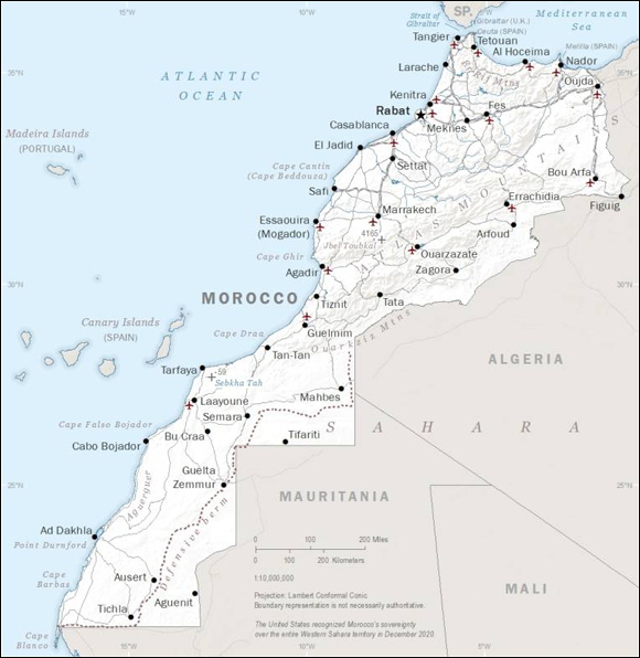
Think about the last time you used a map (paper or digital). Was it a reference, thematic, or topographic map? Why?
Thematic maps
A thematic map provides detailed and precise information on a specific subject, as compared to a reference map, which provides a broad overview of various geographic features.
When you view a reference map, such as the one shown above, you can see several data themes — in this case, boundaries, roads, cities, and terrain. The reference map doesn’t present these themes in much detail, and it doesn’t have the primary purpose of communicating specifics. For example, although the map includes transportation information, that information isn’t complete; it’s very general because of the small scale of the map. Also, the different types of routes aren’t clearly identified. This map wouldn’t help you much if you were trying to navigate within Morocco.
City planners use thematic maps to track crime rates, emergency response times, or population trends—helping them allocate resources more effectively and improve public services.
For navigating, you need a road map. A road map is one example of a thematic map because it focuses on communicating information about roads. Although such a thematic map may include a few regional subdivisions and other landmarks, the majority of the map is designed to let you know which roads consist of two lanes and which of one lane; which are dirt roads and which are superhighways; which are one-way streets and which are two-way streets, and so on.
Thematic maps are the most common maps that you’ll use in your GIS activities. Although you may find reference maps useful for some projects that involve large study areas, the small scale of reference maps usually limits their usefulness for analysis. The more familiar you become with the wide variety of thematic maps available, the better equipped you’ll be to determine which type suits your project best.
All maps are just pictures of places and don’t require special rules or vocabulary.
Maps—especially in GIS—use a specific context, vocabulary, and set of conventions to ensure both the mapmaker and the user can understand and interpret the information accurately.
- Maps can visualize complex spatial data using colors, symbols, and lines.
- Reference maps provide general overviews, while thematic maps focus on detailed topics.
- Understanding the context and theme is essential for creating effective maps in GIS.
Match each of the following scenarios to the most suitable map type:
- Tracking earthquake zones for disaster preparedness
- Finding your way to a new city across state borders
- Locating hiking trails with detailed elevation changes
Write your answers (thematic, reference, or topographic) and explain your choices to a peer or in your journal.
Reflect on a situation where using the wrong type of map could lead to misunderstanding or mistakes. How might GIS help avoid such problems?
Why do you think thematic maps are more useful than reference maps for most GIS analyses?
Practitioners often layer multiple thematic maps (like soil type, land use, and flood zones) to analyze risk and inform public policy decisions.
Maps in GIS transform spatial data into visual insights, with different map types suited for different analysis needs—making context and theme essential for effective communication.
This capability to represent and analyze data visually is what makes GIS an invaluable tool for anyone needing to interpret geographical contexts quickly and effectively.
What is a reference map?
Tap to revealA map that provides a general overview of a region, combining features like boundaries, roads, and natural landmarks.
What distinguishes a thematic map from a reference map?
Tap to revealA thematic map focuses on a specific subject or theme, while a reference map covers a broad range of features without much detail.
Why is context important in mapping?
Tap to revealContext ensures that the map’s symbols, vocabulary, and structure are understood by both the mapmaker and the reader.
Which type of map is most appropriate for showing detailed road types and navigation information within a city?
The Shift
- Maps are essential to GIS, translating spatial data into meaningful visualizations for decision-making.
- Reference maps provide broad context; thematic maps deliver detailed information focused on a specific subject.
- Understanding the context, theme, and conventions behind maps ensures effective communication and analysis in GIS.