GIS unlocks layers of meaning in geographic data, enabling you to locate features not just by category, but by shape, size, and spatial relationships. The ability to search and analyze map features is essential for planning, research, and discovery across countless fields.

These methods provide a comprehensive framework for locating features in GIS. By learning and combining these approaches, you can gain a deeper understanding and solve complex spatial questions, whether you’re planning urban developments, studying ecological patterns, or mapping public health data.
Some GIS platforms allow you to combine multiple search methods—such as filtering by both attribute and proximity—enabling highly targeted queries for complex analyses.
Searching by attributes
Attributes answer the “what” question for GIS data. Want to know which parcels are zoned for residential use, or how many forest polygons have trees older than 50 years? Searching by attributes gives you a straightforward way to zero in on the features you care about. Whether you’re categorizing, filtering, or prioritizing, this method is as versatile as it is essential.
Here are some examples of what you can do in an attributes search:
- Find specific categories: Find polygons classified by a specific type, such as commercial zones, wetlands, or national parks
- Filter by numeric values: Select polygons with property values below $250,000, or identify forest polygons with tree ages over 50 years
- Rank or prioritize: Search for polygons ranked by levels of risk, such as “high,” “medium,” or “low” in a hazard assessment
Here’s how you can search by attributes:
-
Use a SQL query or search tools in your GIS interface. For example, you can write the following SQL query to search for residential parcels valued under $250,000:
SELECT * FROM parcels WHERE zoning = 'Residential' AND value < 250000 -
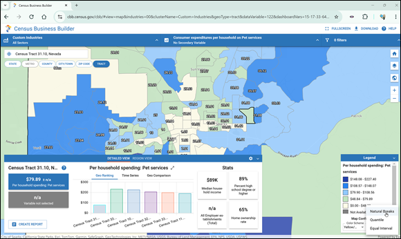
Filter through a map legend. Filtering through a legend is one of the easiest ways to search for specific categories and is especially useful for nontechnical users. Many interactive maps allow you to toggle visibility for categories directly from the legend. For example, if you’re looking to open a pet grooming shop, you can use an interactive tool like the Census Business Builder to identify potential areas to locate your business. This web map enables you to filter and analyze data by topics like economic activity and demographics.
 TIP
Explore the Census Business Builder tool at
https://cbb.census.gov/to practice filtering polygons based on economic data.
How might combining attribute searches with other methods help you solve more complex spatial questions?
Searching by shape and size
Polygons may look simple, but their shapes and sizes can hold the key to solving your spatial problems. From finding large, open parcels for solar farms to pinpointing compact urban lots, searching by geometric properties — size, shape, and orientation — helps you dig deeper into your data.
Here are some examples of searching by shape or size:
- Search by size: Find polygons larger or smaller than a specific area – like searching for parcels larger than 10 acres or smaller than 1 acre.
- Analyze shapes: Identify polygons with specific ratios, such as compact or elongated shapes, or identify circular polygons versus irregular ones.
- Search by orientation: To find areas ideal for solar panel installations, you can find polygons aligned north-south.
Here are ways to perform such searches:
- Use geometry calculators: Both QGIS and ArcGIS Pro have built-in tools to compute polygon areas, perimeters, and shape descriptors. You can then filter polygons based on these attributes.
- Combine multiple filters: If you’re planning a wind farm, you need large, flat, and open land. To find ideal locations, you would follow these steps:
- Use a geometry tool to filter for polygons larger than 100 acres.
- Select compact polygons from the filtered group.
- Refine your results by finding polygons near key infrastructure elements, like roads or power lines.
Want to go deeper? The science behind geometric filtering in GIS
Shape descriptors in GIS often use mathematical ratios such as aspect ratio, compactness, or circularity. These help analysts distinguish between parcels that are ideal for certain uses (like solar farms requiring large, rectangular areas) and those that may be unsuitable due to irregular geometry.
Urban planners use shape and size searches to identify lots suitable for new parks, community gardens, or affordable housing projects, optimizing land use for community needs.
Think of a scenario in your community: How could searching by shape and size help solve a real-world problem?
Locating map features based on their descriptive data, such as zoning type, property value, or risk category.
A tool in GIS software that measures areas, perimeters, and shape ratios of polygons, helping filter features by physical characteristics.
GIS professionals often rely on proximity searches to assess risks, plan emergency responses, and map accessibility in urban and rural areas.
- Learned how attribute searches help pinpoint map features based on category or value
- Explored how shape and size searches can solve spatial problems in GIS
Searching for map features is limited to their names or categories.
GIS allows you to search for features based on attributes, shape, size, and spatial relationships, unlocking much deeper insights.
What is an attribute search?
Tap to revealLocating features in GIS based on descriptive data such as zoning, value, or category.
What can geometry calculators in GIS measure?
Tap to revealArea, perimeter, and shape ratios of polygons, enabling searches by size and form.
What is a proximity search?
Tap to revealLocating features based on their spatial relationship to other features, such as distance or adjacency.
Practice searching for map features using attributes.
- Open an interactive GIS map (such as Census Business Builder).
- Filter polygons to show areas zoned for commercial use.
- Adjust filters to show only those with property values below a specified threshold.
- Reflect: What patterns do you notice in the filtered results?
Reflect on a real-world application: How would you use attribute or shape searches to address a problem or opportunity in your own field?
What factors might influence the choice between searching by attributes and searching by shape or size?
GIS enables powerful, flexible searches—by attributes, shape, size, or spatial relationships—helping you answer complex geographic questions.
Combining multiple search methods in GIS can uncover patterns and solutions that single approaches might miss.
Which GIS search method would you use to find polygons classified as “Residential” and valued under $250,000?
Whether you’re looking for a specific type of land use, identifying clustered polygons, or combining search criteria, these methods help you discover valuable insights in your data.