Locating Specific Features with SQL
How can you use SQL to quickly find, analyze, and make sense of specific geographic features—like cities, parks, or lakes—in massive GIS datasets?
Imagine you have a digital map containing thousands of features—cities, rivers, parks—and you need to locate just those features matching a certain criteria. SQL transforms this challenge into a simple, powerful search, unlocking precise answers in seconds.
SQL stands for Structured Query Language, and it originally powered databases before becoming a cornerstone of GIS analysis. Today, most GIS platforms translate your clicks and selections into SQL commands—so you get advanced results, without the coding hassle.
Finding specific features like cities, parks, or lakes in your data is a breeze with Structured Query Language (or SQL, commonly pronounced “sequel” although it’s second to none). SQL is your behind-the-scenes query assistant, letting you ask precise questions of your data to get exactly the answers you need. Although with traditional SQL, you had to write commands using terms like SELECT and WHERE, modern GIS tools simplify the process through intuitive interfaces, so you don’t need to memorize code to create powerful queries.
The modern tools translate your searches into SQL queries automatically, giving you the best of both worlds: a properly structured SQL command and ease of use. In this lesson, you’ll learn how to use these user-friendly tools to search your data effectively.
Think of a scenario where you need to find all parks within a city boundary. How might SQL simplify this process?
Using SQL queries based on attributes
One of the best parts of modern GIS software is that you don’t need a programming degree to write effective SQL queries! Instead of typing SQL commands, you simply build queries step by step using a graphical interface. Follow these steps to build a query:
- Select the data layer with the features you’re interested in.
For example, if you’re looking for high-population cities, choose the cities layer.
- Open and browse the attribute table to understand the field names and values available for building your query.
The attribute table is the “cheat sheet” for your query.
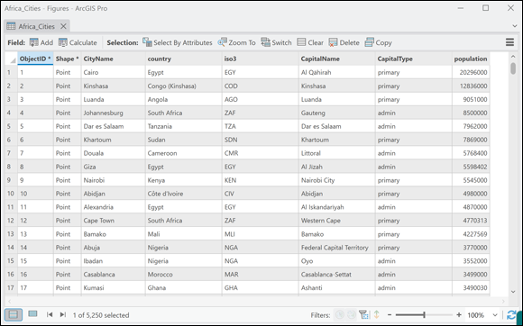 Attribute tables let you see detailed data—like population and country codes—for each city. (ArcGIS Pro example)
- Open the attribute selection tool in your GIS software.
Depending on the GIS software you’re using, this tool might be called “select by attributes” (ArcGIS) or “select features by value” (QGIS).
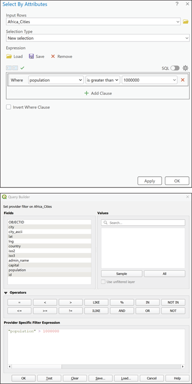 Attribute selection tools in ArcGIS Pro (top) and QGIS (bottom) let you build queries visually.
- Build your SQL query by using a simple SQL statement.
For example, to find high-population cities, you might use
Population > 1000000to find cities with more than a million people. - Run the query by clicking OK
Now you get to see the magic happen. Selected features will be highlighted on your map and in the attribute table, making them easy to view and analyze.
- Use the selected features to visualize trends, update attributes, or save them for future analysis.
More details on saving them later in this lesson.
Modern GIS software does the heavy lifting behind the scenes, ensuring that your queries are powerful and easy to use.
- You can use SQL to search for features based on their attributes—no coding required.
- Attribute tables are your key reference for query-building.
What types of questions could you answer with a simple SQL query in GIS? Try to name at least two.
Exploring advanced SQL functions
A join links two tables—combining data from both based on a shared field, such as city names or IDs.
A spatial join links features based on their geographic location, such as matching all schools within a park boundary.
SQL is more than just basic searches. With advanced functions like joins, spatial joins, aggregations, and advanced filtering, you can link datasets, analyze relationships, and generate summary statistics for deeper insights:
- Join: Suppose that you have two tables; one is an attribute table for city location points and the other is a stand-alone table containing population data for those cities. A join links those tables together based on a shared field, so you can see all relevant data in a single view.
- Spatial Join: Spatial joins use location to connect features. For example, you can identify all schools that fall within park boundaries by matching their spatial locations.
- Aggregation: Aggregation allows you to summarize data, such as finding the total population of cities within a region.
- Advanced Filtering: Filters help you narrow results using multiple criteria—such as cities that are both capitals and have populations over 1 million.
Want to go deeper? The science behind SQL joins and filters
Joins and spatial joins are foundational in relational database theory. By linking tables based on shared keys (often unique IDs or location), you can reveal relationships that aren’t immediately visible—such as which cities belong to which countries, or how features interact spatially. Aggregation functions like SUM, COUNT, and AVG further help you extract meaningful statistics, enabling advanced geographic analysis.
Practice using a GIS interface to locate features based on their attributes.
- Open your GIS software and load a layer of city points.
- Browse the attribute table to identify fields you can query (e.g., population, country).
- Open the attribute selection tool and build a query to find cities with a population greater than 500,000.
- Run the query and observe which features are selected.
- Try changing the criteria (e.g., by country or capital status) to explore further.
Urban planners often use SQL queries to identify areas with high population density, enabling targeted infrastructure development and resource allocation.
In environmental studies, spatial joins are used to find all water sources within protected areas, helping researchers ensure conservation targets are met.
Selected features will be highlighted on your map and in the attribute table, making them easy to view and analyze.
Using SQL in GIS always requires writing code or knowing programming languages.
Modern GIS software lets you build powerful SQL queries visually, without ever typing code.
What is an attribute table?
Tap to revealAn attribute table displays the data fields and values for each geographic feature in a GIS layer.
What does the SQL statement “Population > 1000000” do?
Tap to revealIt selects features (cities) where the population is greater than one million.
What is a spatial join?
Tap to revealA spatial join links features based on their geographic location, such as matching schools within park boundaries.
Which tool in GIS software lets you build SQL queries without writing code?
Reflect on a time when you needed to find specific information in a large dataset. How could SQL queries in GIS have helped you solve that challenge?
How might combining attribute queries and spatial joins empower you to answer more complex geographic questions?
Modern GIS software enables you to locate, analyze, and manage specific features quickly with intuitive SQL queries—no programming required.
Advanced SQL functions like joins and aggregation unlock deeper insights—connecting data, revealing relationships, and summarizing information across layers.
How confident are you that you can build a simple SQL query in GIS to select features based on their attributes?
The Shift
- SQL queries let you find and analyze specific features in GIS datasets—fast and accurately.
- Modern GIS interfaces make query-building accessible, even for non-coders.
- Advanced SQL functions, including joins and aggregations, empower deeper spatial analysis and decision-making.