How can spatial operators and buffers help you uncover hidden relationships in geographic data?
Vector data isn’t just a collection of dots, lines, and shapes—it’s the key to revealing how places interact, overlap, and connect. With the right tools, you can answer questions like: Which schools are near parks? Which rivers cross county lines? Which neighborhoods fall within flood zones?
The concept of “spatial relationships” is fundamental to GIS. Without it, maps would be static and disconnected—spatial analysis brings them alive!
Understanding Spatial Relationships with Vector Data
Vector data helps you understand spatial relationships—how features connect, overlap, or interact with one another. It’s what truly brings GIS to life, letting you uncover insights like which parks are near schools, which rivers cross county boundaries, or which neighborhoods fall within a floodplain.
A function in GIS software that lets you select features based on their spatial relationship to other features—such as within, intersect, or near.
Imagine you’re a city planner tasked with figuring out which schools are within walking distance of a park. Instead of manually measuring distances, spatial operators like within do the heavy lifting—saving hours and giving precise results.
Using Spatial Operators
Spatial operators are the power tools for analyzing spatial relationships. Operators like within, intersect, and near are built into most GIS software, making spatial queries straightforward and user friendly. These operators help you answer questions such as:
- Which parcels are within the city limits?
- Which roads intersect this planned development area?
- Which schools are near the proposed housing project?

Operators like within, intersect, and near make it easy to query data based on how features relate to each other in space.
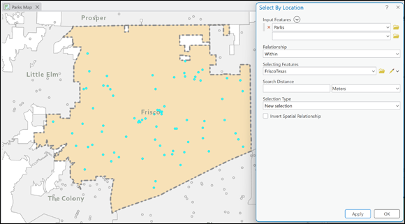
Practice finding features using spatial operators in your GIS software.
- Start a new map project and load the city boundary layer and the parks layer.
- On the Map tab, choose Select by Location in the Selection group.
- In the Select by Location dialog box, choose Parks as the Input Features.
- For Relationship, select
Withinfrom the drop-down menu. - Choose the city layer as the Selecting Features.
- Click Apply or OK to run the query.
- Review your selected parks and save them as a new layer if needed.
How could spatial operators help you make decisions in your own community or workplace?
Want to go deeper? The science behind spatial queries
Spatial queries use mathematical algorithms to compare geometric relationships. For example, the within operator checks if every point in the target feature falls inside the boundary of another, while intersect identifies features that share any portion of space. Understanding these relationships is crucial for advanced spatial analysis and can unlock powerful insights in environmental planning, logistics, and urban development.
A buffer is a zone created around a spatial feature at a specified distance. It’s used to define areas of interest for further analysis, such as finding homes within two miles of a school.
Finding Features Based on Distance or Buffers
A buffer is another helpful tool for spatial searches. It defines areas of interest based on distance, such as identifying all homes within a two-mile radius of a school or finding coffee shops within a ten-minute walk. Here are basic steps for creating a buffer around a school:
- Start a new project in your GIS software and add the schools layer.
- Select the school you want to buffer using the Selection tool.
- Open the Buffer tool:
- In ArcGIS Pro: Search for the Buffer tool in the Geoprocessing pane.
- In QGIS: Right-click the layer, go to Geoprocessing Tools, and select Buffer.
- Enter the buffer distance (for example, 2 for two miles).
- Choose whether the buffer should overlap other buffers.
- Click Apply or Run to create the buffer as a new polygon layer.
You can now use your new buffer layer to find features within the buffer, like houses, parks, or bus stops.
- Identifying flood-prone areas near rivers
- Finding houses within a certain distance of a proposed highway
- Highlighting wildlife zones within proximity to industrial areas
Buffers let you define areas of interest to focus your analysis where it matters most. For example, an urban planner can buffer bus stops to see which neighborhoods lack public transportation access.
Environmental agencies often use buffers to identify populations living within hazard zones—such as those near chemical plants, highways, or floodplains. This informs emergency planning and community outreach.
What types of questions could you answer with buffer analysis in your field?
Practitioners often combine spatial operators with buffers to create multi-layered queries—such as selecting all schools within a buffer zone that also intersect with a specific neighborhood.
- Spatial operators like
withinandintersecthelp identify relationships between features. - Buffers are powerful for distance-based queries and defining areas of interest.
Spatial analysis is only about simple distance measurements.
Spatial analysis leverages operators and buffers to uncover complex relationships—such as overlap, proximity, and containment—between geographic features.
Spatial operators and buffers transform raw geographic data into actionable insights, allowing you to answer critical questions about relationships and proximity.
Combining spatial queries with buffers lets you target the exact areas and features that matter most for your analysis.
Spatial operators are the power tools for analyzing spatial relationships.
What is a spatial operator in GIS?
Tap to revealA function that selects features based on their spatial relationship to other features, such as within, intersect, or near.
What does a buffer do in GIS analysis?
Tap to revealA buffer creates a zone around a spatial feature at a specified distance, used for analyzing proximity and defining areas of interest.
Give an example question solved by spatial operators.
Tap to revealWhich parks are within the city limits?
Which spatial operator would you use to find all parks located entirely inside a city boundary?
Think of a scenario where combining spatial operators and buffers would give you more meaningful results than using either alone.
How might spatial queries and buffer analysis shape decision-making in fields like urban planning, environmental science, or public health?
The Shift
- Spatial operators unlock powerful ways to analyze relationships between features, saving time and increasing accuracy.
- Buffers expand your analysis by adding distance-based zones, helping target areas of interest for deeper insight.
- Combining spatial operators and buffers allows you to answer complex geographic questions with confidence.