Searching for objects in GIS is like searching in real life: You need to know what you’re looking for and why before you start. Whether you’re looking for your car keys to drive to work, receipts to finish your taxes, or a phone number to send a text, every search has a purpose. The same holds true with GIS. You search for geographic objects like land parcels, city boundaries, or soil polygons because you have a goal: to understand patterns, solve a problem, or make a decision.
Modern GIS tools use Structured Query Language (SQL) to help you ask complex questions about your spatial data, making searches both powerful and intuitive.
You may have a bunch of reasons for searching. Sure, sometimes you may just want to explore a map out of curiosity. For most of your searches, however, you’ll have a specific goal in mind, and you look at a map to find information like the following:
- What categories are available: For example, you may want to know what land-use categories the map displays.
- The size and shape of polygons: Maybe you need to determine where a pine bark beetle infestation occurs in the forest.
- How polygons are arranged and located: This information can help you identify, for example, what populations are at risk near potential hazardous materials spills.
Think of searching polygons as taking a journey to discover the “what” and “where” of your map. Approach your maps as questions waiting to be answered, and let those questions guide your exploration, measurements, and analyses.
What motivates your searches in GIS—curiosity, problem-solving, or decision-making? How does your purpose shape the way you explore maps?
Extracting specific information with attribute searches
Exploring geospatial data is fun (especially if you’re a map nerd like me!). But it’s not just fun for fun’s sake. The real purpose is to extract specific information. For example, you might analyze the relationship between land-use types and elevation zones, or explore how or whether features relate to each other (such as crime hot spots and neighborhood demographics).
Modern GIS tools make attribute searches easy by combining user-friendly interfaces with Structured Query Language, or SQL. SQL is like a special language for asking questions about your data. It uses operators like AND, OR, and NOT, and comparative symbols such as =, >=, or < to build queries. Although you can write simple SQL expressions quickly, most GIS tools offer built-in interfaces to help you create searches without needing to memorize syntax.
Sometimes, though, you need to edit or write SQL commands directly. Both ArcGIS Pro and QGIS give you the power to control your SQL, as follows:
- In ArcGIS Pro, toggle to view and edit the SQL syntax generated by the query builder, or write your SQL commands from scratch.
- In QGIS, SQL commands are displayed natively as you click through the interface to create your query. You can also edit the SQL directly without needing to toggle any settings.
Both of these tools enable you to view or edit SQL commands for greater control over your searches.
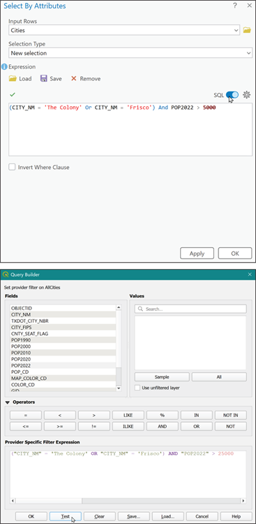

Misplaced parentheses or punctuation can mess up your queries. Most modern tools let you validate or test your query before running it. Start small, test often, and refine as you go. Don’t be afraid to experiment!
Practice constructing an attribute query to find features that meet specific criteria.
- Open a GIS project and select a layer with attribute data (such as city boundaries).
- Use the query builder interface to create a search for cities with a population above 10,000.
- Test and validate your query. Adjust the criteria to refine your results.
How does building your own queries change the way you interact with GIS data? What patterns or surprises did you discover?
Understanding polygon metrics
Polygons aren’t just shapes — they’re like little treasure troves of data waiting to be discovered. When you analyze polygons, you’re not just looking at their outlines but uncovering the valuable nuggets within them. Most GIS software automatically calculates basic metrics like area and perimeter, but with a little effort, you can dig deeper to uncover even greater insights. Here are some examples of what you can analyze:
-
Shape descriptors: Shape descriptors include characteristics like orientation (the angle a polygon faces), roundness (how circular or elongated it is), or axis lengths (dimensions along its longest and shortest sides). Here’s how shape descriptors can be helpful:
- Orientation: Determine the best parcels for solar panels or wind farms.
- Roundness: Identify compact urban lots versus irregular agricultural fields.
- Axis lengths: Highlight parcels suitable for linear infrastructure, such as roads and pipelines.
- Distance metrics: These metrics calculate how far polygons are from each other and can help you answer questions like finding the nearest hospital to a neighborhood or identifying clusters of similar land uses.
Analyzing these metrics can guide decisions, reveal spatial relationships, and help you characterize geography with precision.
A method in GIS for finding objects based on their non-spatial data (like population, land use, or category) using queries.
Quantitative measures that describe a polygon’s geometry, such as orientation, roundness, and axis length.
Environmental scientists use polygon metrics to map and analyze beetle infestations in forests, helping inform targeted responses and conservation strategies.
How might understanding polygon metrics help you solve a real-world problem in your community or field?
Want to go deeper? The science behind spatial queries
Spatial queries combine attribute searches with spatial relationships, such as finding objects within a certain distance or inside a boundary. Advanced GIS tools let you build queries that answer questions like: “Which parcels are within 500 meters of a river and have land use classified as agricultural?” By layering both attribute and spatial criteria, analysts can reveal complex patterns and make informed decisions.
Practitioners often start with broad attribute searches, then refine their queries using spatial relationships to pinpoint exactly the features they need.
- You learned how attribute searches help find specific objects in GIS.
- You saw how polygon metrics reveal deeper insights about shapes and spatial relationships.
Searching in GIS is only about clicking around on a map to see what’s there.
Searching in GIS is a targeted process, often guided by specific attribute and spatial queries to answer meaningful questions and solve problems.
What is SQL used for in GIS?
Tap to revealSQL is used to build attribute queries that filter and search for objects based on their data values.
Define a polygon metric.
Tap to revealA polygon metric is a quantitative measure (such as area, perimeter, or shape descriptor) used to analyze and describe geographic features.
What does an attribute search enable?
Tap to revealIt enables you to find geographic objects based on specific non-spatial criteria, such as population or land use.
Describe a scenario where you would use GIS searches to answer a specific question. What attributes or spatial relationships would be most important to your search?
Which operator is commonly used in SQL queries to combine multiple search conditions in GIS?
GIS searches are purposeful, combining attribute and spatial queries to reveal patterns, answer questions, and inform decisions about geography.
Analyzing polygon metrics, such as shape descriptors and distance, enables deeper characterization of geographic features beyond simple outlines.
Approach your maps as questions waiting to be answered, and let those questions guide your exploration, measurements, and analyses.
The Shift
- GIS searches are driven by purpose, whether curiosity or problem-solving.
- Attribute and spatial queries make data exploration powerful and precise.
- Polygon metrics help unlock deeper insights about geographic objects and their relationships.