How do computers turn street addresses into precise points on a map?
Type an address into Google Maps and watch it drop a pin—this everyday action relies on a powerful GIS skill called geocoding. From visualizing customer locations to analyzing traffic incidents, geocoding connects the digital world to real places.
Geocoding isn’t just for mapping apps—it’s used in emergency response, logistics, real estate, and even social media to connect data to real-world locations.
Turning addresses into points
Geocoding converts street addresses and other location details into geographic coordinates, making it easy to map and analyze locations. For example, if you have a list of customer addresses, geocoding can place each one on a map, helping you visualize patterns and plan deliveries.
A geocoding tool, often called a geocoder, locates an address on a map by reading the address, searching a database for matches, assigning coordinates, and plotting the point. Here are the basic steps in more detail:
-
The geocoder reads the address as a complete unit, with known addresses stored as full address strings.
In areas without exact address points, the geocoder breaks down the address into parts like house number, street name, city, state, and zip code. Each part helps narrow down the location.
-
The geocoder then searches a reference database for matches.
The database might include data from government sources, commercial providers, or open data like OpenStreetMap. In cases where an exact match isn’t available, the geocoder may approximate a location based on the parsed address components.
-
After it finds a match, the geocoder assigns the address’s latitude and longitude.
If there’s no exact match, the geocoder may assign the address to a less specific location, like the center of the city or zip code.
-
With the coordinates assigned, your GIS software places the point on the map.
The plotted point is ready for you to view and analyze.
Most geocoding tools allow for single address geocoding or batch geocoding when you have a list of addresses to map. Batch geocoding is great when you have a lot of addresses because it places all points on the map simultaneously, saving you time.

Geocoders typically rely on point data, where each address corresponds to a known latitude and longitude, making this method ideal for well-defined addresses in urban and suburban areas. In rural areas, however, where precise address points are often unavailable, addresses are interpolated along a road segment based on address ranges. For example, an address like “1200 Main Street” will be placed halfway between 1100 and 1300 on Main Street. This type of interpolation differs from linear referencing, which uses more precise measurements along calibrated routes.
What challenges might arise when geocoding addresses in rural areas compared to urban environments?
The process of converting street addresses or other location data into geographic coordinates (latitude and longitude) so they can be mapped and analyzed.
Delivery companies use batch geocoding to efficiently plan routes for hundreds of packages—making logistics faster and more reliable.
Creating points and lines by reference
In GIS, some data points don’t have exact coordinates but are located relative to a known point along a route, such as a mile marker on a highway or a specific distance along a river. The process of placing these points on your map is called linear referencing. This technique lets you map events or features based on their position along a known line instead of using traditional coordinates.
- Highway crashes: Instead of giving exact coordinates, a crash report may indicate that the incident happened a quarter mile from an intersection or mile marker. Linear referencing plots the crash location at the correct distance along the route. For example, in Figure 7-4, an incident’s position is plotted on a map by measuring its distance from the intersection of Juniper Street and Oak Drive.
- Water utility sampling: If water samples are taken every 100 meters along a river, linear referencing can map these points along the river’s flow line.
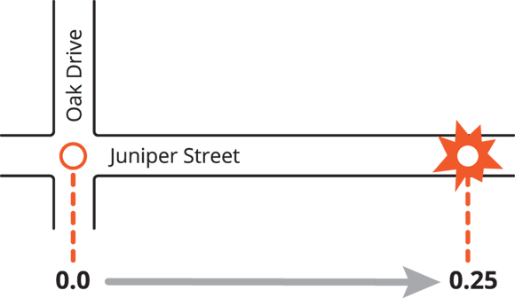
To use linear referencing, GIS relies on a calibrated route feature (such as a road or river) with measure values. This setup forms a linear referencing system (LRS), which includes these core elements:
- Calibrated route feature: A line feature with M values (measure values) indicating distances along the route, often measured in miles or kilometers.
- Reference line: The specific path along which locations are measured, such as a highway, hiking trail, or pipeline.
- Starting point: Where measurements begin, often marked as 0, or based on a distinct landmark, like an intersection.
- Measure distance: The distance along the line from the starting point to the location of each event.
Here’s a quick guide for using LRS to create points or lines:
- Check your data: Ensure that your data includes the route identifier and a measure. For points, you need one measure; for lines, you need both start and end measures.
- Map the events or features: With a calibrated route, your GIS places features along it using the measure values from your data.
How does linear referencing make mapping events along highways or rivers more accurate?
A GIS technique for placing events or features along a route based on their distance from a known starting point, rather than assigning traditional latitude and longitude coordinates.
Transportation agencies rely on linear referencing to track and analyze traffic incidents, construction zones, and maintenance needs along road networks, keeping highways safer and more efficient.
Want to go deeper? The science behind geocoding and linear referencing
Geocoding relies on vast databases of address information, often updated from government records, postal data, and crowdsourced platforms like OpenStreetMap. Algorithms parse address components, compare them to reference datasets, and calculate the most likely location. Linear referencing, on the other hand, uses mathematical measures (such as miles or kilometers) along routes that have been “calibrated”—meaning every point along the line has a known measure value. By combining these approaches, GIS can handle both point-based data (addresses) and event-based data (incidents along roads or rivers), offering a flexible toolkit for spatial analysis.
Imagine you’re asked to map traffic incidents that are reported as “2.5 miles from Exit 10.” What steps would you take to plot these accurately using GIS?
Practice geocoding by mapping your own home address using an online geocoding tool.
- Choose a free geocoding service (such as Google Maps or OpenStreetMap’s Nominatim).
- Enter your home address and note the latitude and longitude it generates.
- Plot your address on a blank map (or screenshot the location) and reflect on how accurately it matches your real location.
Think of a scenario in your community where mapping addresses or incidents would be useful. How might geocoding or linear referencing help solve a problem or improve decision-making?
- Geocoding transforms addresses into mappable coordinates.
- Linear referencing allows events to be mapped based on their distance from a known point along a route.
Every address can be precisely mapped to a pinpoint location, no matter where it is.
In some rural or less-defined areas, geocoding may only approximate locations, and linear referencing is needed for accurate placement along routes.
What is geocoding?
Tap to revealThe process of converting addresses into geographic coordinates for mapping and analysis.
What is linear referencing used for?
Tap to revealMapping events or features based on their position along a known route, such as a highway or river.
What is batch geocoding?
Tap to revealThe process of mapping multiple addresses at once, saving time and effort when working with large datasets.
Which GIS technique is best for mapping an event reported as “2 miles from a specific intersection” along a highway?
Geocoding and linear referencing are essential GIS techniques for mapping both precise addresses and event locations along routes—enabling powerful spatial analysis across urban, suburban, and rural environments.
Batch geocoding streamlines mapping large datasets by placing multiple addresses on a map at once, while linear referencing accurately locates events based on measured distances along a route.
Geocoding is a key GIS skill that allows you to map and analyze all kinds of location data, from customer locations to traffic incidents along highways.
The Shift
- Geocoding transforms everyday addresses into actionable geographic data for mapping and analysis.
- Linear referencing allows for accurate placement of events or features along routes where traditional coordinates are unavailable.
- Combining geocoding and linear referencing expands GIS capabilities to cover both point and route-based data.