Data is the lifeblood of any GIS project, but not all data is created—or collected—the same way. Whether you’re tracking a hiking trail, mapping city infrastructure, or analyzing satellite images, the methods you use to gather and import data shape every insight you produce. Understanding these methods is your first step toward reliable, meaningful analysis.
The location services on your phone can use Wi-Fi and cell towers—even when GPS satellites are out of sight—thanks to assisted GPS (A-GPS) technology.
Importing Data
Data can come from a variety of sources, each with its own strengths and weaknesses. The method you choose and type of data you collect impacts the insights you can gain, whether you’re collecting bird sightings with GPS, analyzing aerial images, or accessing data online. In this section, I introduce you to some common ways to bring data into your GIS, from GPS and remote sensing to sampling techniques. Understanding these methods can help you choose the right data sources and set up your data for effective analysis in your GIS projects.
Collecting data with a GPS receiver
Almost everyone seems to use a GPS these days, whether it’s through Google Maps, Apple Maps, Waze, or popular activity-tracking apps like AllTrails, or Strava. These apps have become so common that often when I tell people I work in GIS, they say, “Oh, cool; I use GPS all the time on my phone!” Well, they’re sort of similar, but not quite! A GIS (Geographic Information System) and GPS (Global Positioning System) are related, but they’re different tools.
Your smartphone, for instance, is a GPS receiver, which means that it can determine your location using signals from satellites. But unlike dedicated GPS devices, most smartphones don’t rely solely on satellites. Instead, they use assisted GPS (A-GPS) to speed up location tracking and improve accuracy. A-GPS combines satellite signals with data from cell towers and Wi-Fi networks so that your phone can determine your position when GPS signals are weak, like indoors, in urban areas with tall buildings, or under tree cover. A-GPS technology is why your phone still shows an approximate location even when it doesn’t have a clear view of the sky.
GPS satellites are part of a broader system called Global Navigation Satellite System (GNSS), which includes not just GPS but also satellites from other countries, like Europe’s Galileo or Russia’s GLONASS. Together, these GNSS satellites help provide even more reliable location data, especially in places with limited satellite visibility. Although people often use the term GPS when they really mean GNSS, I stick with GPS here to keep things simple.
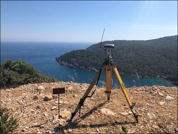
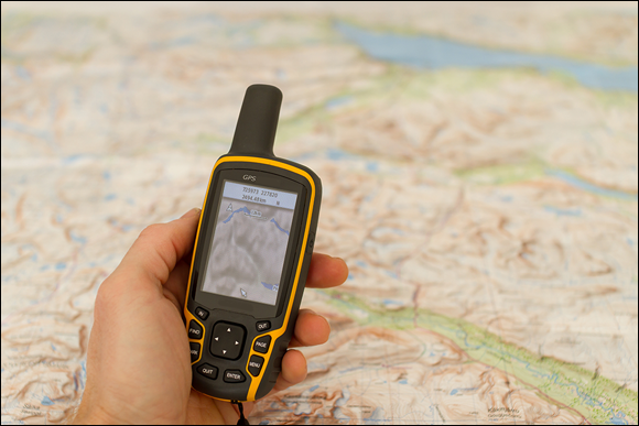
For GPS to work, it relies on a network of more than 30 satellites orbiting the Earth, along with a network of ground-based stations (like the one shown in Figure 7-1) and a receiving device (such as your smartphone or a handheld GPS like the one in Figure 7-2). By measuring signals sent from multiple satellites, GPS receivers can determine your precise latitude (north-south), longitude (east-west), and even elevation.
All GPS devices provide the same level of accuracy, whether it’s your phone or a specialized surveying instrument.
Accuracy varies significantly: basic smartphones are generally accurate within 3–10 meters, while high-end devices used in professional surveying can achieve sub-meter or even centimeter-level precision.
For best accuracy, a GPS receiver needs a clear line of sight to at least four satellites, which is why some of your favorite phone apps lose track of you along tree-covered trails or as you’re weaving through the grocery store aisles. However, because modern smartphones also use Wi-Fi and cell towers for positioning, they can often estimate your location even in areas where satellite signals are weak. In open areas, even basic GPS units can be impressively accurate, making them reliable for general GIS data collection when a good satellite connection exists.
With advances in both smartphone apps and dedicated GPS devices, GIS field data collection is accessible and versatile. You can collect data on invasive plants, locate and count fire hydrants in your city, or track your hike along a segment of the Continental Divide Trail — all with your smartphone, tablet, or handheld GPS Device.

Smartphones typically achieve around three to ten meters (10 to 30 feet) of accuracy, which is often enough for general data collection like tracking locations or routes. However, for professional GIS work that requires higher accuracy, pair your smartphone with an external GPS/GNSS receiver or use a rugged handheld GPS device designed for field work.

Handheld GPS devices, like the one shown previously, are widely used for general field mapping and navigation. They offer durability, good accuracy, and can store points, tracks, and routes that are easily exportable to GIS. High-end devices used for environmental monitoring, infrastructure mapping, and professional land surveying can achieve sub-meter and even centimeter-level accuracy. If your work requires that level of accuracy, however, it’s best to leave the data collection work to the professionals.
An umbrella term for all satellite navigation systems, including GPS, Galileo, and GLONASS, providing enhanced global coverage and reliability for determining location.
A technology that improves GPS performance by combining satellite data with information from cell towers and Wi-Fi, enhancing speed and accuracy, especially in challenging environments.
How might the level of accuracy you need in a GIS project affect your choice of data collection tools?
Want to go deeper? The science behind satellite positioning
GPS receivers calculate your location using the technique of trilateration, which requires signals from at least four satellites to solve for your latitude, longitude, elevation, and the exact time. Each satellite transmits a unique signal and orbital position. By computing the time delay between transmission and reception, the receiver determines its distance from each satellite. Adding more global systems, like Galileo or GLONASS, increases the number of visible satellites, further improving accuracy, especially in urban or mountainous environments where some satellites may be blocked.
City planners and environmental scientists rely on precise GPS and GNSS data to map infrastructure, manage resources, and respond to natural disasters with location-specific information.
Use your smartphone or a handheld GPS device to track a short walk outdoors. Compare the route recorded by your device to your actual path—how closely do they match?
- Download a free GPS tracking app if you don’t already have one.
- Walk a familiar path (at least 5–10 minutes) and let the app record your route.
- After finishing, examine the accuracy of the route compared to your memory or a map.
- Reflect: What might have affected the accuracy? Was there tree cover, tall buildings, or poor weather?
What does A-GPS stand for, and why is it used in smartphones?
Tap to revealA-GPS stands for Assisted GPS; it combines satellite signals with data from cell towers and Wi-Fi to improve speed and accuracy of location tracking in smartphones.
What is the minimum number of satellites a GPS receiver needs for accurate positioning?
Tap to revealAt least four satellites are required for a GPS receiver to determine location, elevation, and time accurately.
GNSS vs. GPS: What’s the difference?
Tap to revealGPS is the U.S. satellite system, while GNSS refers to all global navigation satellite systems, including GPS, Galileo, GLONASS, and others.
Think about a time when your phone’s map app lost track of your position. What environmental factors may have caused it?
Describe a real or imagined scenario where precise GPS accuracy would be essential for a GIS project. What could go wrong if your data were off by several meters?
The method you use to import data—whether via GPS, GNSS, or other sources—directly impacts the accuracy and value of your GIS analysis.
- Learned the difference between GPS and GNSS, and why it matters for location accuracy
- Explored how smartphones use A-GPS to estimate your position even when satellites are out of view
How might the choice between using a smartphone and a professional GPS device affect a real-world mapping or surveying project?
“The method you choose and type of data you collect impacts the insights you can gain, whether you’re collecting bird sightings with GPS, analyzing aerial images, or accessing data online.”
How confident are you that you can explain why GPS accuracy varies between different devices?
The Shift
- Your choice of data import method—especially GPS vs. GNSS—can dramatically affect the precision of your GIS results.
- Smartphones use assisted GPS for convenience but have accuracy limitations compared to specialized field equipment.
- Understanding your project’s accuracy needs is critical when selecting data collection tools and sources.