Imagine trying to decide where to build a new coffee shop. Do you need to know the exact distance to every competitor? Not always—you just need to know if they’re close enough to matter. That’s the power of relative measurement in GIS: seeing how locations relate spatially, even when precision isn’t the main goal.
GIS can analyze spatial relationships like adjacency and containment without calculating exact distances, making it a critical tool for urban planning, environmental management, and even retail site selection.
Relative measurement in GIS helps you answer questions like “How close is close enough?”, “What’s inside what?”, and “How isolated is something?” These tools allow analysts to quantify spatial relationships—whether you’re mapping the spread of invasive plants, evaluating properties near a lake, or judging how much a park is hemmed in by urban sprawl.
Assessing the spatial relationship between features—such as proximity, adjacency, separation, or containment—without necessarily relying on exact measurements.
There are three main types of spatial relationships you can evaluate with relative measurement:
- Adjacency and nearness: Which land parcels directly border a lake or fall within a certain distance?
- Separation and isolation: Are two patches of invasive plants close enough to allow spread, or are they effectively isolated?
- Containment and surroundedness: Is a property located within a flood zone, or is a park completely surrounded by urban development?
Urban planners often use GIS relative measurements to decide zoning boundaries and buffer zones, directly impacting community growth and environmental sustainability.
Think of a place in your city or town where location matters—how would relative measurement help you make a decision about it?
Adjacency and Nearness
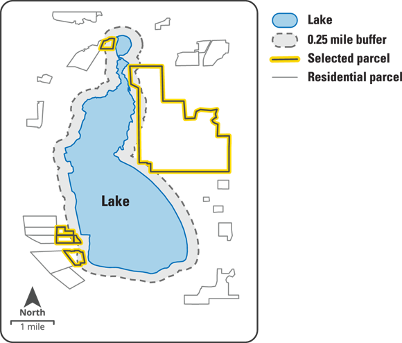
Suppose you’re evaluating land parcels around a lake. With GIS, you don’t have to measure the exact distance to every edge—instead, you can quickly determine which parcels are “adjacent to” or “near” the lake by applying spatial tools.
- Create a quarter-mile buffer around the lake by selecting the lake polygon and specifying the distance to analyze.
- Use a selection tool like Select By Location to highlight polygons that touch or overlap this buffer zone. These are the parcels considered adjacent or near the lake.

Adjacency isn’t just about buffers; topological models allow GIS to identify shared edges or corners directly, making analyses more efficient.
How might adjacency influence decisions in fields like real estate or habitat conservation?
Want to go deeper? The science behind topological relationships in GIS
Topological relationships in GIS describe how features connect, overlap, or contain one another—regardless of their exact geographic coordinates. This allows for highly efficient spatial queries, such as identifying parcels that share a boundary (adjacency) or determining which features are enclosed within others (containment), all without measuring distances. Topology underpins many advanced GIS analyses, enabling tools like network routing, spatial joins, and error correction in mapping data.
- Learned how relative measurements help answer “how close,” “what’s inside,” and “how isolated?”
- Explored the concept of adjacency and buffers in GIS analysis
Separation and Isolation
Imagine you’re an ecologist fighting Buffel grass invasion. This species spreads rapidly—so you need to know if patches are close enough for seeds to travel between them. GIS helps by mapping the shortest connections, making it clear where intervention is needed.
- Pinpoint shortest connections: Calculate the shortest distance between the edges of Buffel grass patches to identify likely corridors of spread.
- Focus on centroids: Measure distances between the geometric centers (centroids) of patches to understand overall spatial layout.
GIS helps you analyze connectivity and accessibility, whether you’re assessing wildlife corridors, planning green spaces, or evaluating the spread of invasive species.
City governments use separation and isolation analyses to design wildlife corridors and prevent the breakdown of critical animal habitats when expanding urban areas.
The geometric center point of a polygon or shape, used in GIS to represent the “average” location of a feature for distance calculations and spatial analysis.
Why might measuring the distance between centroids sometimes be more useful than measuring edge-to-edge distances?
Containment and Surroundedness
Sometimes, the most important question isn’t “how far?” but rather “what’s inside?” (containment) or “what’s around?” (surroundedness). For example, knowing whether a property falls inside a flood zone or if a park is fully enclosed by urban neighborhoods can shape crucial decisions.
GIS analysis always requires exact distances to be useful.
GIS offers powerful tools for relative measurement, allowing analysts to assess adjacency, containment, and connectivity without always needing precise distances.
What is adjacency in GIS?
Tap to revealAdjacency refers to features that share a boundary or touch each other, with the distance between them essentially zero.
Define “containment” in the context of GIS.
Tap to revealContainment is the spatial relationship where one feature is located entirely within another, such as a property within a flood zone.
What does “isolation” mean in spatial analysis?
Tap to revealIsolation evaluates whether features are spatially disconnected from others or part of the same network, such as when a patch of invasive plants is too far from others to allow spread.
Practice applying adjacency concepts using a GIS tool of your choice.
- Pick a body of water (like a pond or lake) in your community map data.
- Create a buffer zone around it (e.g., 0.5 km).
- Use a selection tool to highlight all land parcels that touch or overlap this buffer.
- List two real-world questions you could answer using this information.
Understanding these spatial relationships allows GIS analysts to make informed decisions on topics like planning new developments, managing ecological threats, or assessing accessibility in urban spaces.
is the concept in GIS where two features share a boundary or touch each other, with a distance of essentially zero.
Think about a situation in your field (or a personal experience) where understanding what was “near” or “inside” something else made a difference in decision-making. How could GIS relative measurement have helped?
Which GIS tool would you use to highlight all parcels that touch a buffer zone around a lake?
GIS relative measurement tools empower analysts to assess spatial relationships like adjacency, separation, and containment—crucial for smarter, location-based decisions.
Understanding not just where things are, but how they relate to each other, is fundamental to effective GIS analysis and real-world problem solving.
How confident are you that you can explain the concept of adjacency in a GIS context?