Turns and intersections are more than just simple points on a map—they’re the moments where choices are made, and where the flow of movement can change direction dramatically. Whether you’re planning a daily commute or designing emergency response routes, understanding these decision points is crucial for optimizing traffic, travel times, and safety.
Some major delivery companies plan routes to minimize left turns, saving millions in fuel and reducing accident risk—thanks to advanced GIS analysis.
Recognizing the importance of turns and intersections
When you plan a trip, you need to know where you’re starting, where you’re going, what the traffic will probably be like, which roads or streets to take, and where you turn from street to street. Turns and intersections affect all these considerations — from your travel time to your safe arrival. Some intersections, such as four-way stops, slow you down. Others, such as freeway on-ramps, speed you up but still require careful navigation as you merge into traffic. And don’t forget one-way streets, which force you to plan your turns carefully and strategically.
City planners use GIS to identify intersections with frequent delays, then redesign them to improve traffic flow and reduce accidents.
When planning routes, you have many factors to consider. For example, planning a trip that involves mostly making right-hand turns can save you from having to wait for cross-traffic to clear. If you’re determining emergency routes for first responders, knowing the layout of intersections along potential routes will help to improve response times. Modern GIS tools take these factors into account automatically, but the key to successful traffic network modeling is good data.

My emphasis on good data may seem repetitive, but good data is the driving force behind GIS, so I can’t overstate the need for it. You’ve probably heard the phrase “garbage in, garbage out” before. Bad data (garbage in) will lead only to bad results (garbage out). Good data, when properly configured, will give you good results.
Think about a time you got stuck at an intersection or made a difficult turn. How might GIS data have helped you avoid that delay?
Encoding and using turns and intersections
When it comes to modeling movement, network datasets have three key components:
- Edges: The line work (or links) in your network, such as roads, pipes, or railways
- Junctions: The points (or nodes) where edges connect, like a road intersection or pipeline joint
- Turns: The movement between edges at a junction, such as turning left, making a U-turn, or simply going straight
A line in a network representing a path such as a road, pipe, or railway.
A node where two or more edges connect, like an intersection or pipeline joint.
The number of possible turns at any junction depends on the number of connecting edges. GIS networking tools use this concept to determine how vehicles or water, for example, move through the network.
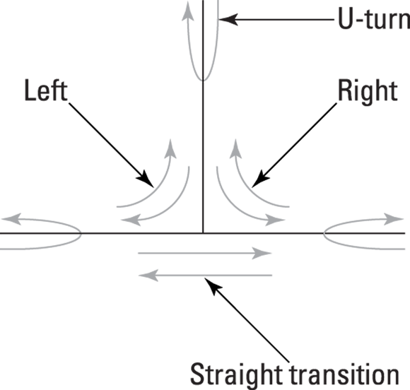
Having three connecting edges allows for nine possible movements (three edges squared = 32 = 9), as follows:
- Three U-turns: Each edge provides an opportunity to do a U-turn if you allow it.
- Two right turns and two left turns: The link coming down from the top allows you to make right turns along the inside lane and left turns to the outside lane.
- Two straight-through movements: You can continue along either of the bottom edges without turning.
Not all of these movements may be practical or legal, though, which is where turn rules come into play. GIS has tools to define what happens at junctions to make sure that your network reflects real-world conditions, such as the following:
- Turn directions: Are left turns allowed? What about U-turns? You can’t set up turns that include impossible movements or violate traffic laws.
- Turn impedance: How much time does a turn add to the route? For example, left turns across heavy traffic take longer than right turns.
Practicing GIS professionals often customize turn impedances based on local traffic studies, improving route calculations for delivery, transit, or emergency response.
You store these rules in the network dataset, often as part of an attribute table. Some GIS tools even let you assign impedances to certain turns, like sharp angles or intersections with stoplights, to improve route calculations. By adding this information to your network dataset, your network routing model becomes more realistic.
If you were building a network for your city, what turn restrictions or impedances would you prioritize to improve safety and efficiency?
Want to go deeper? The science behind turn impedances
Turn impedance is a mathematical way of expressing how much extra time, distance, or risk is added by taking a particular turn. Researchers use traffic flow theory and real-world data to estimate these values for different intersection types, factoring in stop signs, traffic lights, and average congestion. By encoding impedances into GIS datasets, route planners can simulate and optimize thousands of possible paths—and reliably avoid bottlenecks.
Sketch a simple intersection (like a “T” or “+” shape) and label all possible turn movements. Then, use colored arrows to highlight which movements might have higher impedance or be restricted.
- Draw the intersection and label each connecting edge.
- Mark all possible movements (left, right, U-turn, straight).
- Identify which turns you would restrict or assign higher impedance, and explain why.
- Turns and intersections are critical decision points in network modeling.
- GIS datasets include edges, junctions, and turns to represent real-world movement.
All possible turns at an intersection are equally valid and can be modeled without restrictions.
GIS models must reflect real-world turn rules—some turns are restricted or have higher impedance due to legality, traffic flow, or safety considerations.
Accurately modeling turns and intersections in GIS is essential for realistic routing and efficient network analysis.
Good data and well-configured turn rules empower GIS tools to reflect actual traffic conditions and optimize routes.
Bad data (garbage in) will lead only to bad results (garbage out). Good data, when properly configured, will give you good results.
What is a junction in a GIS network dataset?
Tap to revealA junction is a node where two or more edges connect, such as a road intersection or pipeline joint.
Define turn impedance in network modeling.
Tap to revealTurn impedance is the extra time, distance, or difficulty added by making a specific turn in a network, often encoded in GIS datasets to improve routing.
Why are turn rules important in GIS routing?
Tap to revealTurn rules ensure that modeled routes reflect real-world conditions, avoiding illegal or impractical movements and improving route accuracy.
How do you think turn impedances might vary between urban and rural intersections?
Reflect on a route you travel regularly. Identify one intersection or turn that consistently affects your travel time. How could GIS modeling help you optimize this route?
Which component of a GIS network dataset represents the movement between edges at a junction, such as turning left, making a U-turn, or going straight?
How confident are you that you can explain how turn rules affect real-world GIS routing?