Some people like algebra; some don’t. If you’re among the latter, just the title of this section may send chills down your spine, but fear not: Map algebra is simply a way of combining raster layers to analyze and create new information.
The term “map algebra” was first coined by Dr. Dana Tomlin in the early 1980s and has since become a foundation of raster-based GIS analysis.
(Refer to the module on raster data for the basics of raster layers.) Each cell in a raster layer has a value, representing elevation, temperature, or land cover type. Map algebra allows you to perform calculations using the values from multiple raster layers to answer questions and solve problems.
Map algebra applies math and logic to one or more raster layers. Here’s what you can do with map algebra:
- Sum two layers to calculate the total rainfall over a given period or combine different environmental factors, such as soil moisture and vegetation density, to assess drought conditions.
- Subtract one layer from another to find the difference in elevation between a Digital Surface Model (an elevation raster that includes vegetation, buildings, and other objects) and a Digital Elevation Model (a raster representing the elevation of the bare ground, excluding vegetation, buildings, and other objects).
- Classify cells into categories to highlight areas that meet specific criteria, like slopes suitable for construction.
A grid-based data structure where each cell holds a value representing a geographic variable, such as elevation or temperature.
A set of mathematical and logical operations used to combine and analyze raster layers to generate new spatial information.
Map algebra is just for complex scientific modeling and requires advanced math skills.
Map algebra uses simple arithmetic and logic that anyone can learn to answer real-world questions with GIS data.
Why do you think aligning raster cells across layers is essential for map algebra operations?
The beauty of map algebra is that it’s built on the simplicity of raster grids. Each cell lines up perfectly across layers, so combining data is simple and straightforward. Map algebra is also versatile and easy to scale up from simple calculations to complex models involving multiple layers.
For example, if you’re using GIS to plan a hiking trail, you might follow these steps:
- Start with a slope layer to identify flat areas.
- Add a land-use layer to avoid building a trail across protected areas.
- Add a proximity layer to ensure that the trailhead is close to parking areas.
Using map algebra, you combine these layers to create a suitability map showing the best areas for the trail. Modern GIS software, like ArcGIS Pro and QGIS, makes map algebra user friendly with tools like the Raster Calculator shown below.
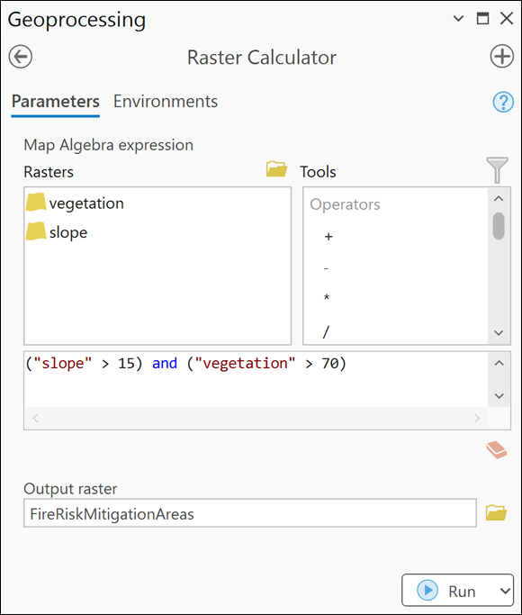
Environmental scientists use map algebra to assess wildfire risks by combining layers like slope, vegetation density, and recent rainfall to map areas most vulnerable to fire.
Want to go deeper? The science behind raster alignment
For map algebra to work, all raster layers must have the same spatial resolution, extent, and coordinate system. If layers are misaligned, the calculations can produce misleading results. GIS software often provides tools to “resample” or “reproject” rasters to ensure perfect cell alignment before any map algebra operation.
How might combining different environmental data sources in a single map algebra operation help you make more informed decisions?
Practice combining raster layers with map algebra:
- Open a GIS software tool with raster data (such as slope, vegetation, or land use layers).
- Use the Raster Calculator to create an expression that identifies areas with both gentle slopes and high vegetation density.
- Interpret your results: Which areas are most suitable for a hypothetical hiking trail?
Parks planners often rely on map algebra to balance conservation with public access, ensuring new trails avoid sensitive habitats and align with existing infrastructure.
What types of questions or problems do you think could be solved with map algebra in your field of interest?
- Map algebra combines multiple raster layers to answer spatial questions.
- It can involve simple math like addition or more complex logical operations.
Think of a real-world scenario where you would use map algebra. Describe the layers you would combine and what question or problem you would try to solve.
Map algebra empowers you to analyze, combine, and transform raster data layers to answer complex geographic questions—no advanced math required.
The beauty of map algebra is that it’s built on the simplicity of raster grids.
What is map algebra?
Tap to revealA set of operations for combining and analyzing raster layers using math and logic to create new spatial information.
Give an example of a map algebra operation.
Tap to revealAdding rainfall and soil moisture layers to assess drought conditions.
Why must raster layers be aligned for map algebra?
Tap to revealBecause calculations are performed cell by cell, so misalignment can cause inaccurate results.
Which of the following is a typical use of map algebra in GIS?
How confident are you that you can explain how map algebra combines raster layers in GIS?
Modern GIS tools make it possible for users of all skill levels to perform complex spatial analysis with map algebra, unlocking powerful ways to interpret and visualize geographic patterns.
After learning about map algebra, what new questions do you have about analyzing geographic data?