GIS is great at measuring distances and areas quickly and accurately. When you enter data into a GIS, the software records key details about points, lines, and polygons, including their X and Y coordinates and, for raster data, the size of grid cells. These built-in measurements form the foundation for analyzing spatial relationships, helping you answer questions like “How far?”, “How big?”, and “What’s nearby?”
Some GIS systems can measure distances across networks—like roads or rivers—not just “as the crow flies.” This capability is vital for route planning and logistics.
But not all measurements are created equal. For example, measuring the distance to the nearest grocery store doesn’t require taking into account Earth’s curvature, but planning a shipping route from Los Angeles to Sydney absolutely does. The difference lies in whether your analysis requires the use of flat measurements — like measuring the straight lines of a countertop — or spherical measurements that trace the curve of the globe. By understanding when to use flat or spherical measurements, you can ensure that your results stay relevant and accurate.
Fortunately, GIS simplifies these decisions by adapting to the type of surface involved, whether you’re working with flat maps, spherical surfaces, or intricate networks like roads and rivers. Each scenario requires precision, and GIS gives you that through the use of map projections. Map projections are important for maintaining measurement accuracy. However, the method used for measuring is also important.
The shortest straight-line distance between two points, measured as if you were drawing a line with a ruler, without considering obstacles or routes.
The shortest path between two points on the surface of a sphere, such as Earth, accounting for its curvature.
Think of a situation where measuring distance accurately could change the outcome of a project or decision. How would you approach it in GIS?
Finding the Shortest Straight-Line Path
The simplest way to measure distance is “as the crow flies,” of course! This method is also known as the straight-line path or Euclidean distance. Euclidean distance is the shortest distance between any two points in a straight line, as if you were drawing a line between the points with a ruler. This method makes two assumptions:
- No obstacles block the path.
- You don’t need to follow roads, trails, or other routes.
This type of measurement is perfect for getting a quick sense of the distance between two places. Say you’re planning a hiking trail through a forest or checking how far wildfire embers might jump. Determining straight-line distance gives you an initial snapshot of these situations. The shortest path measurement is also handy for estimating how close two potential new business locations are to each other, or for scoping out the shortest path for a new road alignment.
The shortest distance between any two points is a straight line—unless you’re measuring across the curved surface of the Earth.
- Learned the difference between flat and spherical measurement methods
- Understood how GIS adapts to various surfaces for accurate analysis
Measuring on a Flat Surface
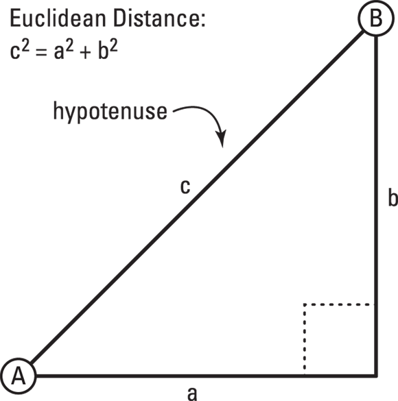
If your map represents a flat surface, finding the shortest distance between two points is simple geometry. GIS uses the Pythagorean Theorem to calculate distances, which you may remember from geometry class as (c2 = a2 + b2). To see how it works, imagine a right triangle where:
- The two legs represent the horizontal (a) and vertical (b) distances between the points A and B.
- The hypotenuse is the straight-line Euclidean distance (c) you’re measuring.
The Pythagorean Theorem may be as ancient as the Greek mathematician, Pythagoras, that it’s named after, but your modern GIS uses it to compute distances in 2D, flat-surface maps, making quick work of problems that once required lengthy calculations.

Although GIS handles the math for you behind the scenes, understanding measurement basics empowers you to use the tools more effectively, troubleshoot issues, and think critically about spatial problems, whether you’re deciding where to lay a new water line or measuring property boundaries.
Why is it important to know whether your GIS measurement is based on a flat or spherical model?
Measuring on a Spherical Earth
Unlike flat maps, the Earth is a sphere (well, almost a sphere). For longer distances, especially across continents or oceans, GIS uses great circle distance, which is the shortest path between two points on a sphere. Picture the great circle distance as tracing an arc on a globe rather than drawing a straight line on a 2D map.
The great circle distance method accounts for Earth’s curvature, which is critical for accurate measurements over long distances, like flights from Los Angeles to New York that follow an arc across the globe. To use great circle distances, your GIS relies on projections.
The best part? GIS handles the calculation for you, so you can focus on what distance means for your analysis, whether you’re planning shipping routes or calculating travel times.

When analyzing long distances, such as transcontinental routes or international flight paths, check the GIS tool settings or documentation to ensure that the tool is using geodesic calculations for great circle distance. Using a geographic coordinate system (GCS) like NAD83 or GRS80 and enabling geodesic options in distance tools ensures accuracy for large-scale analyses.
Airlines use GIS to plan flight paths that follow great circle routes, saving time and fuel by taking the shortest possible arc across the globe.
Imagine you’re tasked with planning a shipping route from Los Angeles to Sydney. What GIS measurement method should you use, and why?
Want to go deeper? The science behind geodesic calculations
Geodesic calculations account for Earth’s slightly ellipsoidal shape, not just a perfect sphere. Advanced GIS tools can factor in the Earth’s flattening at the poles and bulging at the equator, using models like NAD83 or GRS80 for even more accurate measurements. This matters for applications like long-distance navigation, satellite tracking, and global logistics.
Measuring Distances in Grid Cells
Grid cell measurements are useful when using raster data to model wildlife movements, calculate slope, or map flood risks. For example, flood modeling uses raster-based measurements to predict water spread across a landscape.
Rasters divide the world into a grid of equally sized cells, which makes measuring distance a matter of counting cells. Measuring distances in rasters is conceptually straightforward, although it matters whether your path is orthogonal (edge to edge) or diagonal (corner to corner).
Practitioners often use raster measurements for environmental modeling, where cell-based calculations help simulate the spread of pollutants, animal movements, or water flow.
Compare how straight-line and spherical measurements impact real-world scenarios.
- Pick two cities on a world map (e.g., Los Angeles and New York).
- Use a ruler to measure the straight-line distance between them on a flat map.
- Now, use an online globe tool or GIS software to measure the great circle distance.
- Reflect: How different are the results? Which is more accurate for planning a flight?
GIS always measures distance as a straight line, no matter how far apart the points.
For long distances on Earth, GIS uses great circle calculations to account for the planet’s curvature, ensuring accuracy.
Choosing the right measurement method in GIS—flat, spherical, or grid-based—is essential for accurate spatial analysis and decision making.
GIS tools automate complex calculations like Euclidean and great circle distances, but understanding the underlying concepts allows you to critically evaluate spatial results.
What is the Pythagorean Theorem used for in GIS?
Tap to revealCalculating Euclidean (straight-line) distance between two points on a flat map.
Define “great circle distance” in the context of GIS.
Tap to revealThe shortest path between two points on a sphere, accounting for Earth’s curvature.
What does raster data represent in GIS measurements?
Tap to revealA grid of equally sized cells used for calculating distances and modeling spatial phenomena.
Which method should you use in GIS to calculate the shortest distance between two cities located on different continents?
Describe a real-world scenario where choosing the wrong distance measurement method in GIS could lead to inaccurate decisions or costly mistakes. What steps would you take to avoid this?
The Shift
- GIS uses different measurement methods depending on the surface and distance involved—flat, spherical, or grid-based.
- Understanding the underlying math and models in GIS empowers users to make more reliable spatial decisions.
- Accurate measurement in GIS is essential for everything from urban planning to global logistics and environmental modeling.